Not So Fast, 60 - 66. Discovering Peña Trevinca
On Monday, I took one of my days of being out from morning till night. I had really wanted to visit Porto again, but, even though contagion is going down, the idea of being in the midst of a lot of people, having to wear a mask, was off-putting. So, I decided to visit a corner of Galicia I had never been to, Peña Trevinca.
My intention was to try to find a short trail to at least one of the lakes. That was my intention. In reality, I spent most of the morning and early afternoon driving. First, it's a long way away from where I live, over three hours. Second, the habit of not posting comprehensive signage is a bad habit here in Galicia, and what signage there is, tends to take one where one doesn't want to go.
Google Maps doesn't help that much, either, mostly because my phone company doesn't have good coverage up there. I assume there must be some company that does, though there must be areas where there is absolutely no reception for anyone. So, in A Veiga, I followed a sign that told me to go down a narrow road to A Ponte, from which there was a trail to the Lagoa da Serpe, one of the prettiest lakes.

I drove down a long, winding road for over an hour, barely passing any cars, though I did pass through villages. The road ended at A Ponte, an ancient village that is probably more than a thousand years old. The place is beautiful, though the houses suffer from the neglect of beautiful places that no longer offer a means of living, and find themselves gradually abandoned. There, I discovered that the footpath to the glacial lakes was a few more kilometers than I can walk at this moment of fitness. It turned out that I shouldn't have followed the sign down in town that told me to take this route. So, at a moment when my phone had coverage, I figured out a route to join the one I should have taken. Over another hour lost.
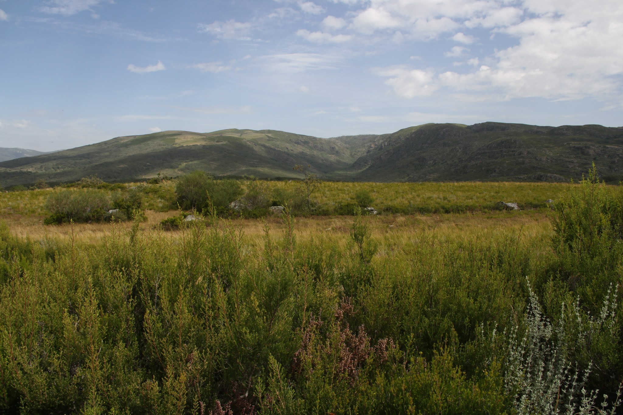
I minded, but I didn't mind, because at the same time, I was discovering an area I had never been before. I passed through villages all clumped together, with paths (those were NOT streets) simply dividing houses from each other. (I'm glad I have an older car that is not very wide.) Many of the houses were abandoned. The few that had people were mostly smarted up, probably because they were vacation homes. I imagine that if I go along the same lanes in winter, most, if not all, houses will be closed up.

I continued driving and reached a village that was almost a town. When I had left the plateau I entered the province of Zamora, but I still heard people speak Galician. There was coverage, and I followed Google Maps through the confusing maze and onto a concrete lane that was one car wide, with deep ditches at either side. From time to time, the concrete disappeared and was replaced with fine gravel. There were pastures scattered about, with stone cabins, most quiet and falling apart, a few tidied up. I assumed they were cow pastures, much like in Cantabria where cows were taken to summer pastures in the mountains, and the cowherd lived in stone houses a lot like the ones I was seeing.

The lane ended and I turned the car around and got out. There was supposed to be a footpath here that went up into the hills before me, to the lake, but I couldn't see anything to mark it. Earlier in the year, it looked like a tractor had been through and cleaned a path, so I followed it. It turned out to be an old cart track, but as I followed it into the hills, I saw that I was getting no closer to crossing over a saddle to where the lake must be, behind the hill to my left. I found myself following a small river through what looked like semi-abandoned pastures. Yet, the tractor seemed to have come this far, and there was a path through the short, dried grass. There was no coverage and I could only see on my phone that the path was taking me away from the lake. I had already walked for a half hour, and it was getting late. Clouds had begun to appear. I wasn't too worried because I was relatively close to my car, but common sense told me to give up the search.

rounded by winter rushes of water from the hills. It had been easy to ford now, in September, but I wouldn't want to try this path in winter or spring. There were wild rosebushes with red hips on them, since there was no one to pinch the withered blossoms. It was so very peaceful. There was no noise of cars, no noise of people, no anything except the wind, and the birds. If my body had been in shape, I wouldn't have minded trying to walk across the peaks. Sitting there, I could understand why people would want to cross mountains.
I went back to my car, and drove back down to the village. A little bit away from where I had been parked, I saw a trail sign. There was the footpath! Well, at least now I know just where to go to try to get to the glacial lakes.
Though the lane was narrow, with nowhere to pull over to one side, I didn't come across any other car. Only three people, who were obviously hiking, passed, walking by me. All the time I was up there, I saw no one else.
I started my drive back, knowing I would still stop wherever my fancy took me, since it was well over a three hour drive home, and it was already close to six in the afternoon. When I got back down to A Veiga, I recognized where I was, and saw the sign that had directed me to the wrong road. Now, I knew for the next time I wandered into these mountains, just where to go.
So, I started the drive back, down to the valley Valdeorras, where tractors were hauling boxes of grapes to be turned into wine. The vineyards stretched out along the hilly land, reminding me so very much of the intro to the prime time soap opera, Falcon Crest. The area looked like a reproduction of California wine country remembered from that show of my teenage years. (Not that I was much of a fan, just of the intro; the show I remembered watching the most was Dallas, especially when J.R. was shot.) Compared to the mountains, the air was hot; 34ºC on my car's thermometer. One last taste of summer.

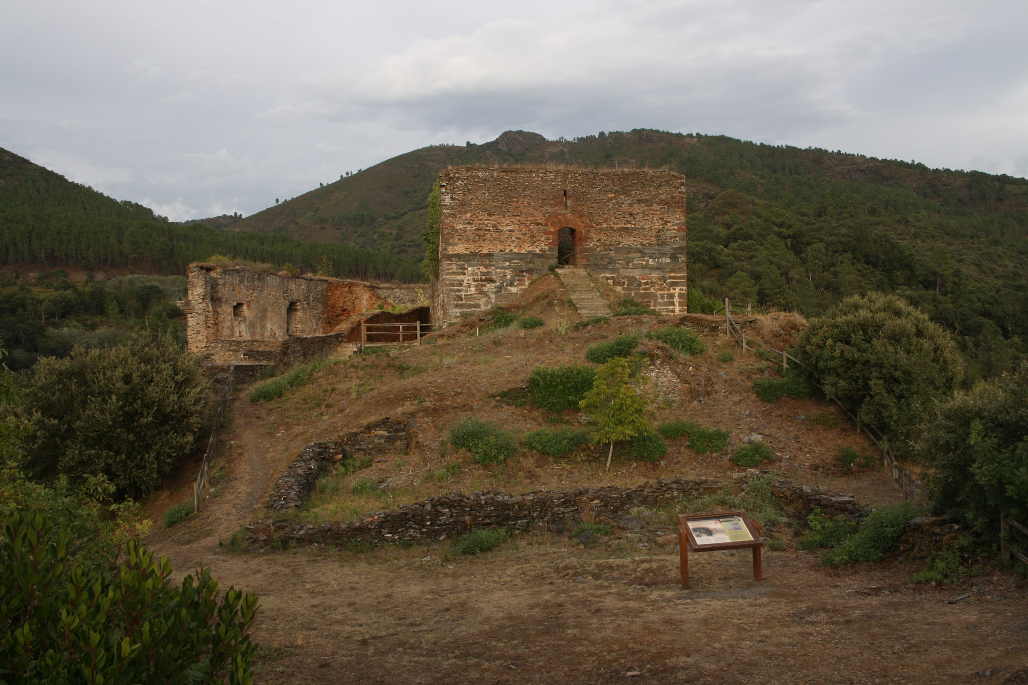
Down in the valley of the river Sil, I stopped first at Montefurado, a village that occupies a piece of the hillside that the Romans mined for gold, using the same method as at Las Médulas, carving tunnels, deviating water down the tunnels, and breaking down the hillside to collect the gold at the bottom. Now, there are irregular columns and the remains of some of the tunnels peppered around the village. One of the villagers even set up a swing chair in the mouth of the remains of one of the tunnels, complete with overhanging awning. I wonder what the Romans would have thought.

I climbed up to the castle and my heart fell as I watched the helicopters carrying water. Ever since I had left A Veiga, I had seen in the distance a pyroclastic cloud of smoke. The fire was before me, in the direction I was headed. The hills along the shores of the rivers Sil and Lor were on fire. The green coolness of the forests were being consumed by voracious flames that someone without a soul had planted. The fire was only stabilized yesterday, with help from the rain. Around 1500 hectares of life was consumed. As I continued home along the road, I could see the lines of the train tracks that run along the river were burning, as well. Smoke rose from different parts of the hills above the valley, red flames hungrily licking the wailing trees. The fire had crossed the road at one point, which must have been cut off; firefighters were still throwing water on black vegetation at the sides. The welcoming folds of the hills that hang over the road are now dead and black. Whoever did this deserves to be pitched into the middle of his works.
When I got home, it was around ten thirty, and already night, since we're in September. The day hadn't gone as I had expected it would, but it hadn't been a loss, either. Having taken a picnic lunch with me, and found bathrooms, even natural ones, helped a lot. I discovered the silence and peace of the mountains, and found where I want to return, whenever that might be.
Life continues.


Nice road trip. Maybe one day I'll do it.
ReplyDelete